About Village
Kottarakkara is a village under kottarakkara taluk office in Kollam District in Kerala State. it lies near kottarakkara railway station, it is about 2KM west to Kottarakkara Sri Maha Ganapathi temple. The boudaries are Railway Station in the north, N.H. 47 in the south, muncipality road in the east and kollam schengottai railway line in the west. Staff Strength: 7
Demography
According to the 2011 census, Kottarakkara village has population of 586434. Out of which 274,103 are males while 312,331 are females. In 2011 there were total 152,944 families residing in Kottarakkara Taluk. The literacy rate of Kottarakkara Village is 88.15% and the average Sex Ratio of Kottarakkara Taluka is 1,139. As per Census 2011 out of total population, 5.1% people lives in Urban areas while 94.9% lives in the Rural areas. The average literacy rate in urban areas is 96.4% while that in the rural areas is 94.3%. Also the Sex Ratio of Urban areas in Kottarakkara Taluka is 1,116 while that of Rural areas is 1,141. The population of Children of age 0-6 years in Kottarakkara Taluka is 54514 which is 9% of the total population. There are 27613 male children and 26901 female children between the age 0-6 years. Thus as per the Census 2011 the Child Sex Ratio of Kottarakkara Taluk is 974 which is less than Average Sex Ratio ( 1,139 ) of Kottarakkara Taluk. The total literacy rate of Kottarakkara Taluk is 94.42%. The male literacy rate is 86.77% and the female literacy rate is 84.66%
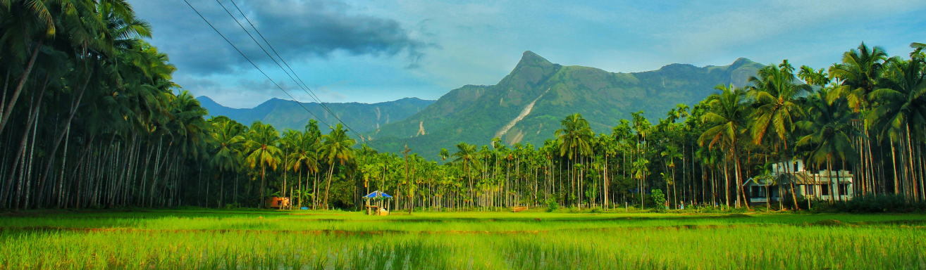
Geography
Kottarakkara is a muncipality close to Kollam. . It is surrounded by several other towns. The town is close to Kollam Port, which has a rich history linked to the early medieval period as well as the reputation as an important commercial, industrial and trading center. Kottarakkara lies 27 kilometres to the east of Kollam city NH 744 earlier known as NH 208 (Kollam to Thirumangalam) meets the MC road (Thiruvananthapuram to Angamaly) at Kottarakkara. Kottarakkara is linked with Kollam (the district headquarters), both by road and rail, at a distance of 27 km The municipality is located in the heart of Kottarakkara taluk and is equally rural and civilized. Kottarakkara panchayat was elevated to a municipality on January 14, 2015. BORDERS North Mylam Panchayat. West Neduvathur Panchayat. South ummannoor and Veliyam panchayats. East Melila and Vettikkavala panchayats.
Socio-Economic
The Socio economic population of this village belongs to upper, middle, lower class. Govt. Employees, Businessmen professionals like Doctors, Engineers, Advocates,and ITs are here. Daily labourers and small scale traders are also here. They belongs to normal economic living standards. State Institute of Rural Development, Kottarakkara ,now renamed as KILA-CHRD,located at Thrikkannamangal , which offers training for different categories of Government officials, elected representatives of Panchayats and members of non-governmental organisations who are engaged in developmental activities in the State is situated in this village.It is also a major research and consultancy center on various faces of rural development.IHRD Engineering College, Jawahar Navodaya Vidyalaya are also situated in this village.Many Schools,clinics, small hospitals, religous institutions, hotels are situated in this village. The Taluk Head Quarters Hospital, the First Referal Hospital is also situated in this Village.National Highway, State Highway Kollam Schengottai Railway Line Passess through this Village. kottarakkara has one of the keralas well connected KSRTC Hub Consists of Various Services across almost all the parts of kerala is also located in this village.
Ecology
Climate in this area is normal.Most of the Places are Plane areas. Ponds, canals, thodu, paddy fields and agricultural lands are also present.Pulamon thodu passess through this village. The height of most areas is between 20 m and 80 m. According to the topography, the municipality can be divided into 6 main areas. The valley Slightly sloping area Medium sloping area Moderately sloping area Mountains Hilly areas The highest point of the place is the Ambalappuram Junction which is located at an elevation of 100 m. There are generally three types of soils found here. Rocky loam, laterite and loamy soils. They cover a large area as the rocky soil is suitable for rubber cultivation. Aerated laterite soils are common in the municipality. These are mostly used by the locals for housing and mixed farming. The loamy soils found in the valleys are fertile for agricultural crops and are found in considerable quantities in the total area of the municipality.
Tourism
Kottarakkara is a vast developing town and muncipality in kottarakkara taluk. The best attractive places in kottarakkara are 1.Sri Maha Ganapathy Temple Kottarakara Ganapathy Temple is one of the famous temples in south india with great historical importance. There are many legends about Kottarakara Ganapathy. Actually the main ‘Prathistha (Idol) is Lord Siva, but Ganapathy is famous here. The exact name of the temple was Kizhakkekara Siva Kshethram. The main deity is none other than Lord Siva himself, Siva facing eastward. In fact Ganapathy is only a minor deity here. But the temple today is famous as a Ganapathy temple rather than a Siva temple.Along with the name Kottarakkara Ganpathy Temple, the other name that instantaneously strikes one’s mind is Kottarakkara Uniappam. It was also the first offering of the famous sculptor Perumthachan, who carved the idol of Mahaganapathy and enshrined Ganapathy at Kottarakkara. It was actually six to seven unaiaapams stringed together and made as an offering, which is otherwise known as Koottappam.It is believed that the world famous art form of Kerala, took birth in the land of Ganesa, Kottarakara. Kathakali took form in the seventeenth century. There are some legends behind its origin. One day Kottarakara thampuran, requested the Zamorin of Kozhickode, Manaveda, to send a team of Krishnanattam performers for a festival. But the Zamorin sarcastically denied the request. This was an insult to the Thampuran. Kottarakara Thampuran went to the Ganapathy temple and pleaded for a way. Then on the surface of his mind arose the plan to create a new art form. He sat on the banks of the temple’s pond looking in to the water. There he saw different shapes of waves in scintillating colour combinations. From this experience Thampuran created the costume designs of Kathakali. He wrote Ramanattam sitting beneath the banyan tree near the temple. Thus it was as a reply to the Zamorin’s sarcasm that Thampuran created a new art form, Ramanattam. This art form later developed into Kathakali. 2. Meenpidi para. Meenpidi Para is one of the most beautiful and scenic places in Kottarakara. It comes under the Kollam tourism sector. The waters at Meenpidi are to have healing properties. The water flowing through medicinal herbs reach the falls which maybe the reason for the medicinal properties.Hundreds of tourists visit the place for herbal bathing every year.Tourists are provided an option for trekking in Meenpidi. The place is situated not so far from the town so public transportation could be availed. . The place has been maintained under Kollam Eco-tourism project.