Goverment of Kerala

Revenue Department

Bambrana
Village Office

Official Web Portal

TOURIST PLACES

Arikady Fort

കാസർഗോഡ് ജില്ലയിൽ കുമ്പളയിൽ ആരിക്കാടി ഗ്രാമത്തിലാണ് കോട്ട സ്ഥിതി ചെയ്യുന്നത്. ഏറ്റവും അടുത്ത റെയിൽവേ സ്റ്റേഷനും ബസ്സ്റ്റാന്റും കുമ്പള ആണ്. മാംഗളൂർ അന്താരാഷ്ട്രവിമാനത്താവളം ആണ് ഏറ്റവും അടുത്ത വിമാനത്താവളം.

Arikady Fort

According to the South Canara Manual, the Keladi Nayakas (1500-1763) who had their capitals at Keladi, Ikkeri and Bednore in Karnataka built few forts in the Hosdurg-Kasargod region of Kerala.[3] Arikadi Fort is one of them. According to historical records, Arikady Fort was built by Ikeri Hiriya Venkadappa Nayak in the year 1608.[4] In the second volume of the South Canara District Manual, Stuart records that there was an inscription in Kannada at the entrance to the fort, which states that the fort was built by Nayak.[4] Other histories are also being told. Most commonly, it is believed that the fort was built during the reign of Tipu Sultan.[4] Another belief is that it was built for the headquarters of the Kumbala dynasty.[4] Another belief is that the fort existed during the reign of the Kolathiri Rajas and that after the collapse of the Kolathiri kingdom and the Vijayanagara Empire, the area came under the control of the Ikkeri Nayakas and they rebuilt the forts.[3] Some historians say that the fort was under the rule of the Maypadi Kovilakam, which had jurisdiction from Kumbala to the Chandragiri river.[2] The area was under their control during the heyday of the Vijayanagara Empire, which was later handed over to the Nayaks of Bednore and the local king acted as their feudatory.[2] After the fall of the Vijayanagara Empire, it fell into the hands of the Mysore rulers and after the defeat of Tipu Sultan by the British, the fort fell to the British control.[2]

Arikady Fort

Arikadi fort is a fort located in the Kasaragod district of Kerala, India. It is also known as Kumbla fort. The fort is located at a distance of 2 km from Kumbla on the NH 66 National Highway. Excavations by a team from the Department of Archeology, University of Kerala in 2015 uncovered a large hall possibly meant for congregation. The excavation was carried out as part of the 'A Survey of Forts' research project jointly funded by the University Grants Commission (UGC) and the University of Kerala. Excavations have also uncovered large quantities of roof tiles, local pottery, Chinese pottery, lead bullets and the mold used to make them. According to the South Canara Manual, the Keladi Nayakas (1500-1763) who had their capitals at Keladi, Ikkeri and Bednore in Karnataka built few forts in the Hosdurg-Kasargod region of Kerala. Arikadi Fort is one of them. According to historical records, Arikady Fort was built by Ikeri Hiriya Venkadappa Nayak in the year 1608. In the second volume of the South Canara District Manual, Stuart records that there was an inscription in Kannada at the entrance to the fort, which states that the fort was built by Nayak. Other histories are also being told. Most commonly, it is believed that the fort was built during the reign of Tipu Sultan. Another belief is that it was built for the headquarters of the Kumbala dynasty. Another belief is that the fort existed during the reign of the Kolathiri Rajas and that after the collapse of the Kolathiri kingdom and the Vijayanagara Empire, the area came under the control of the Ikkeri Nayakas and they rebuilt the forts. Some historians say that the fort was under the rule of the Maypadi Kovilakam, which had jurisdiction from Kumbala to the Chandragiri river. The area was under their control during the heyday of the Vijayanagara Empire, which was later handed over to the Nayaks of Bednore and the local king acted as their feudatory. After the fall of the Vijayanagara Empire, it fell into the hands of the Mysore rulers and after the defeat of Tipu Sultan by the British, the fort fell to the British control.

Read More

About Village

Bombrana village is located in Manjeshwaram Taluk of Kasaragod district in Kerala, India. It comes under Manjeshwar assembly and Kasaragod parliamentary constituency. Kasaragod is nearest town to Bombrana which is approximately 19km away. This locality is an essentially multi-lingual region. The people speak Malayalam, Kannada, Tulu, Migrant workers also speak Hindi and Tamil languages.

Demography

Bombrana is a large village located in Kasaragod Taluk of Kasaragod district, Kerala with total 676 families residing. The Bombrana village has population of 3759 of which 1778 are males while 1981 are females as per Population Census 2011. In Bombrana village population of children with age 0-6 is 493 which makes up 13.12 % of total population of village. Average Sex Ratio of Bombrana village is 1114 which is higher than Kerala state average of 1084. Child Sex Ratio for the Bombrana as per census is 1098, higher than Kerala average of 964. Bombrana village has lower literacy rate compared to Kerala. In 2011, literacy rate of Bombrana village was 88.09 % compared to 94.00 % of Kerala. In Bombrana Male literacy stands at 92.74 % while female literacy rate was 83.92 %.

Geography

This village hase an extent of 879.16 acre. Local roads have access to National Highway No.66 which connects to Mangalore in the north and Calicut in the south. The nearest railway station is Kumbla on Mangalore-Palakkad line. There is an airport at Mangalore.

Socio-Economic

The Hindus, Muslims,and the Christians, live side by side, each influencing and getting influenced by the culture of the other. Communal harmony and religious tolerance are the noteworthy characteristics of the people.Though the people speak different languages there is no barrier on the cultural unity. Mosques, Temples and Churches stand side by side as symbols of communal cohesion

Ecology

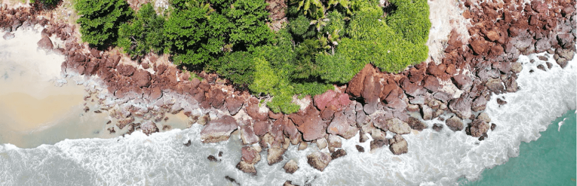
Shiriya river is passing by the side of this village. In the Kumbla-Shiriya Estuary one can see White-bellied Sea Eagles (Haliaeetus leucogaster), Lesser Crested Terns (Thalasseus bengalensis), Greater Crested Terns (Thalasseus bergii), Common Terns (Sterna hirundo) Eurasian Oystercatchers (Haematopus ostralegus) and other birds. Eurasian Oystercatcher is an uncommon, winter visitor and can be seen in seashores and mudflats at estuaries .

Tourism

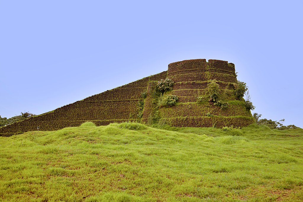
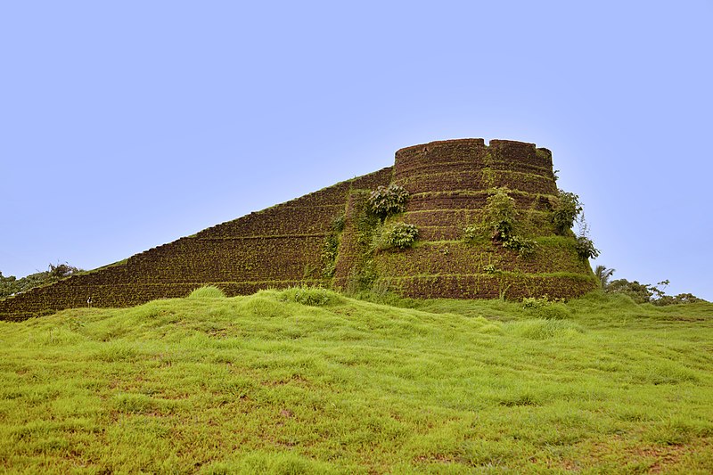
Arikady Fort is nearby tourist spot. It is also known as Kumbla fort. The fort is located at a distance of 2 km from Kumbla on the NH 66 National Highway. There is a Hanuman temple just below the fort.